Qeshem Island
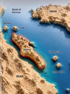
Qeshm Island (also spelled Gheshm or Qeshm, Persian: قشم) stands as the largest island in the Persian Gulf and is celebrated as one of Iran’s most remarkable natural and cultural gems. Shaped like an arrow or a dolphin, Qeshm stretches along the strategic Strait of Hormuz—a vital maritime corridor linking the Persian Gulf to the Gulf of Oman and serving as a crucial chokepoint for international oil and gas transportation. The island belongs to Hormozgan Province in southern Iran and is separated from the mainland by the narrow Khuran Strait (also known as Clarence Strait), with its closest point just about 2 kilometers from the coast.
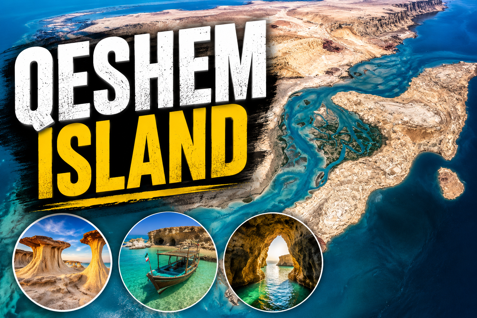
The main town, also named Qeshm, is located at the island’s eastern tip, approximately 22 kilometers from the port city of Bandar Abbas on the mainland. Qeshm Island is renowned not only for its strategic significance but also for its unique geological formations, diverse wildlife, and rich cultural heritage. The island is home to spectacular natural attractions such as the Hara mangrove forests, the mysterious Valley of Stars, and the Chahkooh Canyon. Its coastline features pristine beaches and traditional fishing villages, while its interior is dotted with ancient sites, vibrant bazaars, and evidence of centuries-old maritime trade. Qeshm’s blend of natural beauty, biodiversity, and cultural history makes it a fascinating destination for travelers and researchers alike.
The island is renowned for its extraordinary geological features and landmarks, which play a significant role in its designation as a UNESCO Global Geopark. Among these highlights are the Namakdan Salt Cave, Valley of Stars (Dareh Setaregan), Chahkooh Canyon, and the expansive Qeshm landscapes. These areas are characterized by unique eroded formations, intricate salt structures, dramatic canyons, and the lush mangrove forests that define the island’s natural beauty.
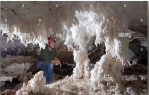
- Namakdan Salt Cave:One of the world’s longest salt caves, Namakdan is nestled within a massive salt dome. Visitors are captivated by its dazzling crystalline salt formations, vividly colored layered walls, and impressive stalactites and stalagmites that have formed over thousands of years.
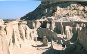
- Valley of Stars (Dareh Setaregan):This surreal landscape is famous for its wind- and water-eroded rock pillars, mushroom-shaped formations, and deep canyons. The area’s otherworldly appearance, especially during sunset or golden hour, creates a scene reminiscent of a star-studded sky.
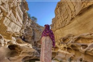
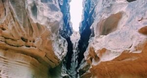
- Chahkooh Canyon:A breathtaking slot canyon, Chahkooh features narrow corridors, towering stratified rock walls, and intricate erosion patterns sculpted by wind and occasional flash floods. Its dramatic scenery makes it a favorite among explorers and photographers.
- Hara Mangrove Forests:The island’s diverse geology also includes the iconic Hara Mangrove Forests, a vital tidal ecosystem dominated by dense stands of Avicennia marina trees. These forests provide crucial habitat for wildlife and contribute to the island’s ecological richness.
Qeshm’s geological diversity extends beyond these landmarks, encompassing eroded plateaus, rugged mountains, and a variety of unique landforms. Together, these features not only shape the island’s striking scenery but also underscore its global geological significance.
Geography and Size
Qeshm Island, the largest island in the Persian Gulf, stretches approximately 135 km in length and reaches a maximum width of about 40 km, narrowing to just 9–11 km in certain areas. Covering a total area of around 1,491 km², Qeshm is larger than Bahrain, Singapore, and even surpasses the size of several sovereign nations.
Despite its relatively compact size, Qeshm boasts a remarkably diverse landscape. The island features rugged mountains—its highest point being Bukhun Mountain at around 370–400 meters—alongside striking salt domes, expansive mudflats, sandy beaches, dramatic canyons, fertile valleys, and rich coastal ecosystems. The geology of Qeshm dates back hundreds of millions of years, with dramatic rock formations sculpted by erosion, salt tectonics, and ancient seabed processes. This unique geoheritage has earned Qeshm recognition as a UNESCO Global Geopark, celebrated for its salt caves, erosional landscapes, and other geological wonders.
The climate of Qeshm is hot and arid, characterized by high humidity typical of the Persian Gulf region. Summers, from June to September, are extremely hot and humid, with temperatures frequently soaring above 35–45°C (95–113°F), making outdoor activities challenging during these months. In contrast, winters and the shoulder seasons (November–March or April–May) bring milder, more pleasant conditions, with temperatures ranging from 15–25°C (59–77°F), ideal for exploration and outdoor adventures. Rainfall is scarce throughout the year, but the island occasionally experiences tropical influences, bringing brief periods of heavier rain and humidity.
Qeshm’s strategic location at the mouth of the Strait of Hormuz has also shaped its history and development, making it a crossroads of trade, culture, and biodiversity. The island’s varied habitats support a rich array of flora and fauna, including mangrove forests, coral reefs, and important nesting sites for sea turtles and migratory birds. This combination of geological, ecological, and cultural significance makes Qeshm a unique destination in the region.
Qeshm Island boasts a rich and intricate history shaped by its strategic maritime location along ancient trade routes that connected Mesopotamia, India, Africa, and other regions—integral to the broader Silk Road networks. In antiquity, the island was known as Abarkavan during the Sasanian era, flourishing with palm groves, agriculture, and vibrant maritime activity. Over the centuries, Qeshm experienced waves of conquest and governance by various powers, including the Elamites, Umayyads, Abbasids, and later, European colonial forces.
The Portuguese occupied Qeshm for nearly two centuries from the early 16th century, constructing a formidable fortress—whose ruins still stand—and leaving their mark on local architecture and even some street names. In 1622, a joint Persian-English campaign expelled the Portuguese in a decisive battle that claimed the life of British explorer William Baffin. Subsequent influences from the Dutch, English, and other powers further shaped the island’s role in regional trade and naval conflicts.
Today, Qeshm preserves a vibrant Bandari (southern Iranian coastal) culture, renowned for its traditions in fishing, dhow (lenj) shipbuilding, embroidery, mat weaving, and lively festivals. The island is home to diverse ethnic and linguistic communities, and its sacred sites and shrines—such as Seyyed Mozaffar and Bibi Maryam—as well as historic villages, reflect a unique blend of Persian, maritime, and Islamic heritage. Architectural highlights include the traditional wind towers (badgirs) in the old village of Laft, ingeniously designed for natural cooling in the island’s warm climate.
Qeshm is equally celebrated for its extraordinary geological and ecological features, many of which are protected or promoted for sustainable tourism:
- Hara (Mangrove) Forests: Among the island’s most iconic natural wonders, these vast networks of Avicennia marina mangroves (locally called Hara trees) line the northern and northwestern coasts, forming part of the UNESCO-designated Hara Biosphere Reserve. These trees thrive in saline, tidal waters through remarkable adaptations, acting as natural desalination systems. The ecosystem supports rich biodiversity, including migratory birds (flamingos, herons, egrets), dolphins, sea snakes, fish, and shrimp. Boat tours through the “floating forest” offer tranquil views, especially at high or low tide, making it a prime destination for eco-tourism and birdwatching. The reserve spans thousands of hectares and is one of the largest mangrove systems in the region.
- Valley of Stars (Dareh Setaregan): This surreal landscape features eroded rock pillars and canyons sculpted by wind and water, creating star-like or mushroom-shaped formations. It is a favorite spot for hiking and photography, particularly at sunset.
- Chahkooh Canyon: A dramatic, narrow canyon with layered rock walls, often compared to slot canyons elsewhere, offering geological beauty and adventurous hiking opportunities.
- Namakdan Salt Cave: One of the world’s longest salt caves (over 6–6.6 km explored), located within a massive salt dome. The cave features crystalline salt formations—some of the purest in the region—and has historical significance for salt and sulfur mining. It is a standout geosite within the Qeshm Geopark and holds international geological importance.
- Naz Islands and Beaches: These small offshore islands and coastal areas are known for their clear waters, corals, colorful fish, and oysters—ideal for boat trips, snorkeling, or relaxation. Shib Deraz beach is especially notable for sea turtle nesting (April–July).
- Other Highlights: Nearby Hengam Island is famous for its wildlife, including dolphins. The Portuguese Castle ruins, Laft village with its traditional architecture, and various canyons, valleys, and mud volcanoes add to the island’s allure. Qeshm’s geodiversity also includes Rainbow Valley-like colorful strata in certain areas.
The island’s wildlife encompasses marine mammals, diverse bird species, and unique desert-adapted animals. Qeshm’s natural and cultural heritage faces challenges from climate change, development, and pollution, making conservation efforts crucial to balance tourism with environmental protection. Today, Qeshm stands as a living testament to centuries of cultural exchange, maritime enterprise, and natural wonder, inviting visitors to explore its layered history and breathtaking landscapes.
Economy and Modern Role
For generations, the people of Qeshm have relied on fishing, traditional crafts, and local trade as the backbone of their livelihoods. In recent decades, however, the island’s economic landscape has transformed significantly with the establishment of the Qeshm Free Trade Zone in the early 1990s. This initiative has invigorated the local economy by offering incentives for commerce, industry, tourism, and logistics, positioning Qeshm as a dynamic regional hub.
The Free Trade Zone has attracted investment and facilitated the growth of diverse industries, including gas and oil-related activities—particularly in the island’s central areas, where reserves have been identified. Shipbuilding, logistics, and tourism have also flourished, supported by the development of modern infrastructure such as ports and transportation networks. The island’s duty-free shopping centers draw visitors from across the region, further boosting trade and retail activity.
In recent years, Qeshm has experienced a notable increase in trade turnover and economic activity. However, broader challenges facing Iran—such as inflation, international sanctions, and regional tensions—continue to impact the island’s economic prospects. Qeshm’s strategic location near the Strait of Hormuz adds another dimension to its modern role, making it a focal point in discussions about energy security, maritime routes, and geopolitical significance.
The island’s population is estimated to range between 120,000 and 150,000, with some sources indicating ongoing growth. Most residents are concentrated in the main town and surrounding villages, where population density remains moderate. While many locals continue to engage in traditional livelihoods, there is a growing trend toward participation in new economic opportunities brought about by the Free Trade Zone and related developments. This blend of heritage and modernity shapes Qeshm’s unique social and economic character today.
Despite Qeshm Island’s remarkable natural beauty, unique geological features, and immense tourism potential—making it an ideal destination for Iranians and visitors from neighboring countries—the Islamic Republic of Iran has transformed this free zone into a heavily militarized area, imposing strict Islamic restrictions and curtailing many freedoms. The Islamic Revolutionary Guard Corps (IRGC) has played a central role in this process, focusing on the construction of extensive underground facilities, the development of asymmetric naval capabilities, and the establishment of firm control over the Strait of Hormuz.
Over several decades, this militarization has steadily intensified, but it has drawn unprecedented international scrutiny in 2026 amid escalating regional tensions involving Iran, Israel, and the United States. Qeshm’s strategic location—its vast size, proximity to the strait, and natural features such as salt caves, rock formations, and tunnels—makes it exceptionally well-suited for hardened, survivable military infrastructure. The island dominates the eastern approaches to the Strait of Hormuz (via the Clarence/Khuran Strait) and lies just 22 kilometers south of Bandar Abbas. With approximately 20% of the world’s oil trade and significant liquefied natural gas shipments passing through the strait, Qeshm sits at the heart of one of the globe’s most vital maritime chokepoints.
Iran’s military doctrine in the Gulf emphasizes asymmetric warfare, aiming to deter or disrupt superior naval forces—particularly the U.S. Navy—by threatening to close or destabilize the strait. Rather than relying on conventional fleet engagements, Iran employs swarming tactics, sea mines, anti-ship missiles, drones, and fast-attack boats to create a persistent threat to maritime traffic.
The IRGC Navy (IRGCN), which operates independently from Iran’s regular navy and answers directly to Supreme Leader Ali Khamenei, leads these operations in the Gulf. Qeshm Island serves as a forward operating base for a range of advanced military assets, including:
- Anti-ship cruise missiles (such as Noor, Khalij Fars, and their variants)
- Ballistic missiles and coastal defense systems
- Naval drones, including suicide/shahed-type drones adapted for maritime use, and unmanned surface vessels
- Fast-attack craft—small, high-speed boats armed with rockets or missiles, ideal for shallow waters and swarming tactics
- Sea mines and related deployment systems
Military analysts, including retired Lebanese Brigadier-General Hassan Jouni, describe these developments as part of an extensive underground “missile city” network, explicitly designed to control or threaten the closure of the strait. Due to its size (approximately 1,491 km²) and capacity to host dispersed, hardened military assets, Qeshm has been dubbed Iran’s “unsinkable aircraft carrier.” The island’s transformation underscores its dual identity: a place of extraordinary natural wonder and a linchpin in Iran’s regional military strategy.
In addition, the IRGC has constructed numerous tunnels and underground facilities on Qeshm Island. Iran has strategically leveraged the island’s natural salt caves, canyons, and unique geological formations to develop an extensive network of tunnels and missile silos. These underground structures are engineered for earthquake resistance and are equipped with advanced ventilation, power systems, and rail transport for rapid missile deployment. They are also designed to withstand airstrikes, enhancing survivability under sustained attack. Reports describe these as “vast subterranean labyrinths” capable of housing a wide array of weaponry that can be quickly brought into action. Recent IRGC-released footage has revealed tunnels containing fast-attack boats, anti-ship missiles, naval mines, and drones mounted on rail launchers. While the exact number and full layout of these facilities remain classified, their primary purpose is clear: to ensure operational continuity and deterrence even under heavy assault.
The IRGC maintains several known naval bases on Qeshm, including the 112th Naval Combat Brigade located on the south-central shore near Shib Deraz and Messen. There are also suspected drone airfields and coastal artillery batteries. The island’s defenses are further bolstered by watchtowers, logistical staging areas hidden in mountain ridges, and mobile weapons systems that complement the underground infrastructure. Historically, since at least the 1990s and 2000s, the IRGC has deployed mobile anti-ship missiles—such as Silkworm variants—on the island, underscoring its long-standing military significance.
Since 1989, Qeshm has operated as a free trade-industrial zone, promoting tourism, commerce, and infrastructure development. This dual-use status allows for civilian projects—ports, airports, and roads—that can also support military logistics, providing plausible deniability and economic cover for military activities. However, recent reports indicate that the military overlay has increasingly overshadowed the island’s tourist and commercial aspects, particularly in sensitive southern and central regions.
This military buildup is part of a broader IRGC strategy across Gulf islands such as Abu Musa, the Tunbs, Sirri, and Larak, as well as along the mainland coast. However, Qeshm’s scale, location, and infrastructure make it uniquely significant in Iran’s regional defense posture.
The military presence on Qeshm is not new. References to anti-ship missile deployments, marine reinforcements, and IRGC activity date back to the 1980s and 1990s, particularly during periods of heightened tension such as the “tanker war.” The IRGC has long used the island for coastal defense and asymmetric warfare training. The development of underground “missile cities” accelerated in the 2010s and 2020s, taking advantage of the island’s geology. By early 2026, amid escalating U.S.-Israel-Iran tensions, Qeshm had become a focal point, with reports of expanded facilities for drones, missiles, and swarm boats.
2026 Conflict Context: Qeshm has played a direct role in recent hostilities. U.S. strikes have targeted IRGC naval and drone bases, tunnel complexes, airport fuel tanks, and even a desalination plant—impacting civilian water supplies in local villages. Satellite imagery has confirmed damage to bunkers and surface infrastructure. Iran has reportedly used assets from Qeshm in retaliatory operations. Western analyses have discussed potential U.S. scenarios for seizing or neutralizing Qeshm to secure the Strait of Hormuz shipping lanes.
Despite the heavy militarization relative to the island’s civilian population (estimated at 120,000–150,000) and its tourist appeal, not every area is fortified. The northern mangrove forests (Hara Biosphere Reserve) and some eastern and western tourist sites (such as the Valley of Stars and Laft village) remain primarily civilian or ecological, though dual-use infrastructure is present. The full extent of military facilities is opaque due to classification and restricted access; most claims rely on satellite imagery, defector and intelligence reports, IRGC propaganda footage, and expert assessments. Wartime reporting can sometimes exaggerate the scale of militarization.
The IRGC’s facilities on Qeshm enhance deterrence by complicating enemy targeting through hardened, dispersed, and mobile elements. However, they are not invulnerable—U.S. and Israeli strikes have reportedly damaged surface access points, bunkers, and related infrastructure. A full closure of the Strait of Hormuz would have catastrophic global economic consequences, including oil price spikes and supply disruptions, but would also isolate Iran economically and provoke overwhelming retaliation.
This posture fits within Iran’s broader “forward defense” and anti-access/area-denial (A2/AD) strategy in the Gulf. Critics argue it is destabilizing, while Iran frames it as a matter of defensive sovereignty. Regional rivals such as the UAE and Saudi Arabia view it as a direct threat, and it is closely tied to ongoing disputes over other Gulf islands. In a wider conflict, Qeshm could become a flashpoint for amphibious operations, prolonged insurgency, or significant environmental damage—such as harm to mangroves or coral reefs from mining or airstrikes.